Although Dave is the king of GPS around here, I had my own Eureka moment after my recent smartphone upgrade. While traveling along I-95 in Maryland a few weeks ago, it suddenly occurred to me to use my new Android phone to check on traffic conditions. After a quick look through the app store, I installed the Inrix app and enjoyed instant access to traffic alerts throughout the region. The traffic widget uses GPS to find your current location, and provides an interactive map with roads labeled in green, orange, and red depending on traffic delays.
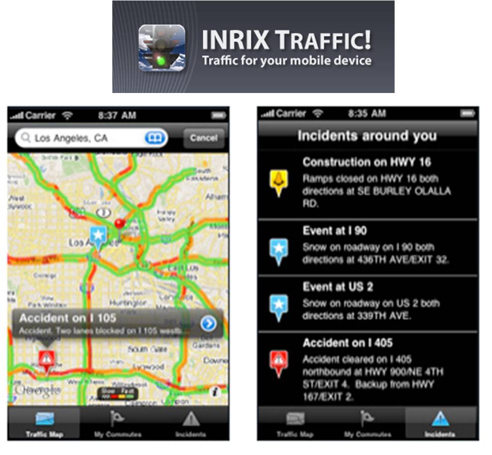
After my gratifying mobile experience with Inrix, I was delighted to run into the company again a short while later, this time in person at CES. Naturally the folks there had something new to show off, and I was a willing audience to their booth demo. As of January 6th, there is now an Inrix Traffic! Pro app available for the iPhone. Instead of just color-coded maps, the premium version of the application also provides estimated ETAs depending on your location and destination, predictive traffic information, the ability to record your favorite routes for traffic comparisons, and access to real-time traffic cameras. It’s $10 for a year or $25 for a lifetime subscription. It’s not available for the Android platform yet, but likely will be in the future
But wait, there’s more. Inrix has been using its traffic data to produce national traffic reports, and third-party groups are now doing the same. News site The Daily Beast just used Inrix data to determine the worst commutes in America. (Top three are on freeways in L.A., Honolulu, and the DC metro area) Although the data analysis in this case is relatively simple, the amount of raw data that Inrix is collecting means that future data analysis projects could be significantly more ambitious. Imagine using Inrix data for city planning, or to create alternative traffic management systems. (A way to avoid congestion pricing?) Inrix is already spreading to smartphones, to smart cars, and through state transportation contracts. The company relies on its own “Smart Dust Network” with information from road sensors, commercial vehicles, toll tags, weather forecasts, events and school schedules. Smart Dust? Maybe the Internet of Things has officially arrived.
A number of mapping services and GPS providers license Inrix data so there are other places to get it. And speaking of other places, once HTC upgrades your Eris smartphone to Android 2.*, you can install the free Google Maps Navigation app which includes traffic. (Not sure who provides it though, for some reason I think it’s Navteq.) Unfortunately, live traffic is still imperfect despite the growing number of data points.
“…you can install the free Google Maps Navigation app which includes traffic. Not sure who provides it though…”
The data’s source is…Us!
“…If everybody on the road could tell the world how fast their car is moving, and we could make it easy for anybody to check that information on their computer or cell phone, well — then we’d be getting somewhere.
If you use Google Maps for mobile with GPS enabled on your phone, that’s exactly what you can do. When you choose to enable Google Maps with My Location, your phone sends anonymous bits of data back to Google describing how fast you’re moving.
When we combine your speed with the speed of other phones on the road, across thousands of phones moving around a city at any given time, we can get a pretty good picture of live traffic conditions. We continuously combine this data and send it back to you for free in the Google Maps traffic layers. It takes almost zero effort on your part — just turn on Google Maps for mobile before starting your car — and the more people that participate, the better the resulting traffic reports get for everybody.”
http://googleblog.blogspot.com/2009/08/bright-side-of-sitting-in-traffic.html
Todd, the base data is augmented by users. Same as we did at Dash. Unlike Dash, I believe the first source of data is Navteq traffic, as opposed to INRIX. Once/if Google hits a critical mass they can unsubscribe, but the road sensor and fleet data is a good place to start.
Does Inrix install their own sensors? Or do they acquire data from other providers?
I believe they do work directly with some fleets, but it’s my understanding that the road sensors themselves are provided by, managed by the local municipalities.
I should also add, I am QUITE familiar with the traffic situation here. It’s why I moved last summer. Commutes under 30 miles should not take 90 minutes.
The problem with the DC Metro area traffic is that any alternative routes are well known and they’re just as bad, if not worse, than the primary traffic arteries.
Thomas
Commute is I-95/152B going North to I-95/166A – 24miles door-to-door – 50-60minutes on a good day
Plus there’s only so many bridges over the Potomac… which is where my choke point (on the beltway) usually was. That 8 mile stretch often took 30-60 mins alone. Why? Had to move.
Google uses their own data fused with data from Airsage (which seems to be down right now as they integrate the 90 million cell traces from Verizon into the ones they have from Sprint) and TrafficCast (public sensors and fleet probes). Probably the best traffic data available.
Inrix head Bryan Mistelle blew a gasket in an interview at the thought of Google’s data being more accurate than their’s.
Inrix has access to sensors that are public but some cities sensors are owned by Navteq despite being paid for with taxpayer money and Inrix does not have access to those. There are something like 33 metro areas where the sensors are owned by Navteq.
I’ve been using the (free) Inrix app on my iPhone lately as well, both to get the traffic info at a glance and to supply them data as a good citizen. Since it scrolls automatically as I drive, something the Google Maps application DOESN’T DO, I’ll continue to use it until they fix that. I do suspect that at some point I’ll be switching to a Google product though, so I DO suspect they’ll have the best data over the long run.
Mostly though, I’d just like all this stuff integrated with a GPS Nav application, one with automatic traffic-based routing with automatic detours. Feels like I’ll be waiting a while for the successor to the Dash though, but I’m sure its coming nevertheless.